
In addition to the paved and granular multi-use trails, there is an
extensive network of informal natural-surface (dirt) trails that weave their
way throughout Taylor Creek Park. These
trails are used by hikers, dog walkers, school and day-camp
groups, nature enthusiasts and mountain bikers. In part one I discussed the
various things to see and experience while running on the paved trails; in this
part I will discuss the informal dirt paths and what you can expect when
running on them.
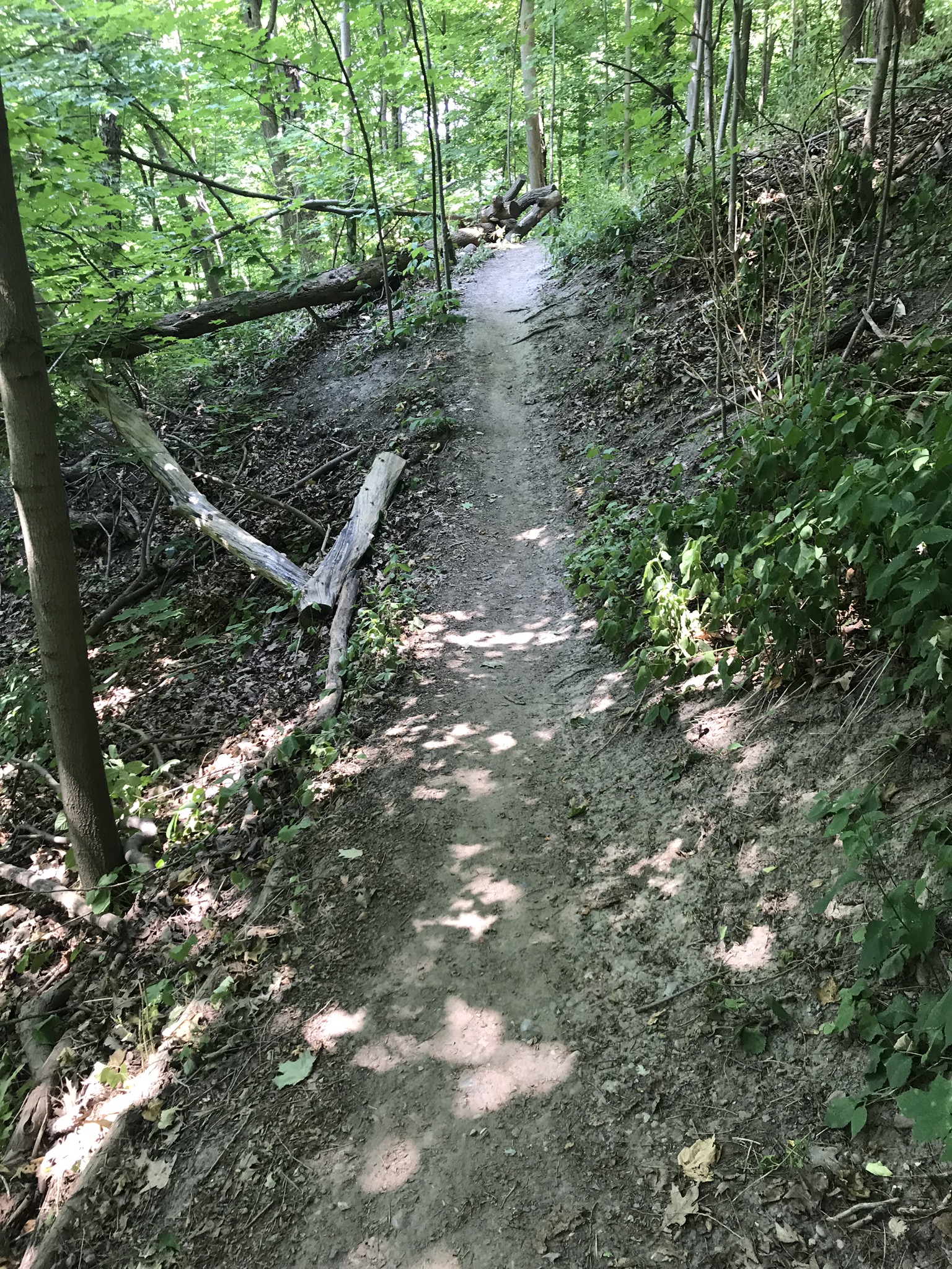
Trail running is very different from running on
concrete or asphalt. It can be more challenging because of the obstacles that
you have to dodge, climb or leap over such as tree roots, rocks, water and even
fallen trees. Unlike the multi-use path in the park, the natural surface trail
is far from flat, with many jaunts up and down the ravine making it a much
tougher and exciting workout. Pace will be slower as a result, but you will be
working different muscle groups, so it’s a worthwhile trade-off.
The trail begins just east of Dawes Road and ends
under the DVP underpass near Don Mills Road. It is a 3.5 kilometre point to
point trail that uses mostly dirt paths that lead you alongside Taylor creek,
while other times deep through the forested areas. There are many different paths that you can take--this is one option.

There is a set of stairs that leads under Dawes Road
Bridge. After you pass under Dawes Road and cross the pedestrian bridge, you
will see an area to the left that was planted with serviceberry, grey dogwood,
basswood and sugar maple. The hillsides to the right, where the Park Vista
Apartments are, were brickyards at one time and later were used as landfill
sites.

Once in the park, there is a narrow single track dirt
path to follow. Taylor Creek is on the right. The paved path is just on the
left.

Just before the half kilometre mark you will reach a
steel bridge on the right that crosses over Taylor Creek and is an access point
to the park from Hasley Avenue.

Cross over the bridge and once on the other side, turn
left to run on the right side of Taylor Creek. The path is wide and flat, the
terrain mostly gravel and packed dirt making it easy to run fast.

At kilometre .50 there are some beautiful views of the
creek.


The trail turns into a sandy single track that travels
right against the edge of the water. Shortly after the trail widens again.

A little further there is a set of stairs on the right that take you up to Glenwood Crescent and a bridge on the left that takes you onto the paved path on the south side of Taylor Creek. Ignore both and pass between them, following the dirt path up the left side of the stairs.

It is a steep climb with stones and tree roots.

Taylor creek is still on the left side, peeking at you between the trees and various plants. The trail is now single track, and trickier to navigate with tree roots, stones and other tripping hazards.


At kilometre 1.84 you will cross under the Woodbine Bridge.


At kilometre 2 there is a wire fence holding back some
of the debris that has fallen from the side of the ravine. On May 5th, 2017 around four feet of the
roadway broke off and collapsed into the ravine. It is believed that heavy rain
saturated the root of a tree on the embankment, along Glenwood Crescent near
O’Connor Drive and Woodbine Avenue, causing it to erode, along with the
asphalt, and crumble off the side of the roadway and into Taylor Creek. The
road and the ravine wall has been fixed since then with this fence the only
evidence of the avalanche.

At around the 2 kilometre mark the trail is very
narrow and balanced right on the edge of the creek. There is wire mesh embedded
into the path, part of a gabion basket that is preventing further erosion of
the riverbank. I’m not sure if the erosion is from all the traffic on the
trail, or it’s just a natural occurrence.
There are many of these gabion baskets throughout the
creek banks. Some are in great shape, while others are falling apart.
Gabion baskets are wire mesh containers made from double
twisted, hexagonal woven wire mesh. Once assembled, the baskets are filled on
site with durable stone in order to create flexible, permeable, monolithic
structures.


Soon after you will cross a wooden bridge which passes
over Curity Creek, a small tributary of Taylor Creek.

After crossing the bridge run about 300 metres and
you’ll come across 2 trail openings on the right. They’re hard to find as
they’re just small openings through the trees. I took the second path.
This part of the trail takes you into a deciduous
forest with a variety of tree species including sugar maple, red oak, white
oak, white ash, basswood, beech, black cherry, white elm, mountain maple,
Manitoba maple, and an understory of trillium, trout lily, bloodroot, Virginia
waterleaf, blue cohosh, false Solomon’s seal, wild ginger, zigzag and
blue-stemmed goldenrod and wild leek.
You are taken deeper in the trees, up the ravine, and
away from the creek.

Muddy sections are often found along flat sections of trail where water collects or in areas with seepage. Because no one likes going through mud, the vegetation on both sides of the trail become trampled due to trail users trying to avoid getting wet feet. Unfortunately these muddy areas then become wider and leads to major soil structure disruption, soil displacement and widening of trails. Someone has placed a little bridge to try to curb this tendency.

At kilometre 2.72 you will come across the top section of the Alder stairs.


It’s very peaceful and secluded. You feel like you are
miles away from the city.

Just after the 3 kilometre mark, an illegally built fire pit.

At kilometre 3.20 you reach a clearing where there is
a picnic circle with a fire pit. Pass over the grass to the woods on the other
side and you will find the entry to the trail.


This part of the trail has you reuniting with Taylor
Creek. The path is mostly sandy, flat and narrow. There are some blind spots so
be careful of cyclists coming toward you.


The trail ends under the Don Valley parkway overpass at the 3.50 kilometre mark. There are other nature trails you can connect with that will weave throughout the Don Valley system. Another option is to run along the paved path that goes along the Lower Don Trail, or cross the concrete bowstring bridge and run north through the various parks.


No comments:
Post a Comment